Showing posts with label Wild Rivers. Show all posts

Sunday, May 5, 2013

We found spring on the Western Waterfront Trail

Sure it's May 5th already. But when I told Sally I wanted to go for a hike this Sunday afternoon, her question was obvious, "Where?" As in, "Are you crazy, everything is snowy, muddy or crowded." 

Duluth's Western Waterfront Trail is a reliable destination for an early spring hike, even when early spring comes in early May like this year. The wide gravel trail dries out early. Migrating waterfowl fill both inviting stretches of open water and the various grassy mudflats around the edges. 

As I recommend in my book Hiking the North Shore, we headed for the obscure eastern trailhead of the Western Waterfront Trail, on 63rd Ave. West. From there you can hike three miles along Duluth's upper St. Louis River estuary. Despite the sunny weather, we had the trail nearly to ourselves. The poodle was stuck on the leash, and had a great time sniffing up all the smells coming out of the thawing ground.


The trail did sustain some damage in last year's June flood, and things are still stabilizing. At one place, a stream had chosen its own crossing about fifty feet away from the old bridge and one hundred feet away from the new culvert. But it's still in excellent shape overall.

So while you're waiting for the Superior Hiking Trail to emerge from winter, and if you don't want to deal with the crowds on the Duluth Lakewalk or the paved paths of Gooseberry Falls, head for the Western Waterfront Trail.

Warbler Walks on the Western Waterfront Trail
If it's a Tuesday in May, head for the Western Waterfront Trail at 6:30 AM for Duluth Audubon Society's annual spring warbler walks. Bring your binoculars!

Monday, April 29, 2013

North Shore Waterfalls: Stay close to shore

Signs warning Gooseberry Falls visitor
Just in the last few days, the waterfalls of the North Shore, from Duluth to Grand Portage, have shed their curtains of ice and are starting to roar. Record late snowfall will feed these falls for weeks to come as the woods slowly release their snowy load.

River ice from the Gooseberry pushed up against an old cedar
The ice on the rivers must have just broken up in the last week. Along the banks of the Gooseberry River today, foot-thick chunks of river ice were piled up against the ancient cedar trees that hold the banks against the milky flood. 

Unfortunately for us fans of waterfalls, it will be tough going to see these torrents up close. The snowpack still reaches all the way to the lakeshore. At Gooseberry Falls State Park, where at least a foot of snow is found in the woods around the visitor center and much more inland, signs warn visitors to the most popular falls to use ice cleats (and "CAUTION"). 

How do I know?
I decided this morning to check out one of my favorite North Shore waterfall hikes. It's Hike #17 in my book Hiking the North Shore: 50 Fabulous Day Hikes in Minnesota's Spectacular Lake Superior Region. It's a three-mile hike that runs up one side of and down the other of the Gooseberry River, bringing you to all five of the park's main waterfalls.

Upper Falls, Gooseberry River
It was easy going on the wide paved path as far as Upper Falls, the blocky fall right above Highway 61. Then it got snowy. And slushy. And wet.

Andrew on Fifth Fall Bridge
Slippy through the slush along the southwest bank, I made it all the way to Fifth Falls, where I crossed the river on the incredibly scenic footbridge. The northeast bank of the river had more sunshine on it and was a bit less snowy. And a bit more muddy. It was tough going.

Other parks, same story
This pattern of snowy slushy hiking on North Shore waterfall hike is true all the way up the shore. The snow gets deep fast as soon as you head inland from the lake and from Highway 61. Another favorite waterfalls hike, the Split Rock River loop on the Superior Hiking Trail, is probably deep in wet snow along the west side of the river.

For the best waterfall hiking on the North Shore this week, stick close to the lake and on well-used paths. If you have cleats for your shoes, strap them on; last thing you want is to slip off the well-packed trail down the gorge and into the just-melted river water rushing away.

Broken up river ice below Middle Falls, Gooseberry River
In Gooseberry, the basic trail around Middle and Lower Falls is in decent shape. People were strolling around in shorts and sneakers, despite the warnings. The famous Middle Falls is as scenic as anything else in the park. The stacked-up pile of broken-up river ice near the base of the falls shows the power of the river at break-up. At Cascade River State Park, the short loop around the lower river is good for hiking, with some mud and some occasional ice spots.

So you should definitely go check out some North Shore waterfalls this week or next. By the time the great hiking trails dry up, the waterfalls might have dried up too.

Sunday, June 24, 2012

Beachcombing after the flood

The great flood of June 2012 is still receding, and we are just now grasping the full scale of its impact. While most of the attention is rightfully on the washed out roads and thousands of moldy wet basements, the trails enjoyed by North Shore hikers, bikers and nature enthusiasts have also suffered greatly. More details to come in a future post.

Five days now after the rains, the first big chunks of debris have arrived on the Park Point beach here in Duluth. It's a tragic treasure hunt, sorting through all this stuff that was, until very recently, someone's backyard tree, someone's dockside ornament, even someone's dock or home. 


I walked the beach from the "Tot Lot" at 12th St. to the Aerial Lift Bridge this afternoon and found mostly sticks and logs, but also some funky personal items. A kids sandal. Two different empty bottles of UV Vodka. A foam toilet brush. The most bizarre was a stuffed cat with a straw hat tied into a willow bedframe. 


Perhaps most telling were the lily roots. Looking like sea anemones at low tide, these freaky plants had obviously been scoured out of the mucky quiet river bottoms where lily pads thrive. The tuberous lily roots then spent the last five days sending out sprouts out looking for light to grow and new muck in which to grow. They weren't finding any on the beach

It was an amazing storm. Even along the shores of Lake Superior, the clean up will take some time.

Monday, April 23, 2012

Canyoneering in Utah, thinking of Minnesota

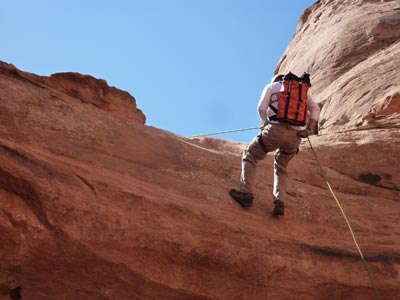
Hans on the first big rappel. Not as scary as the last one, though.

Earlier this month, the Slade/Rauschenfels clan took our spring break week, added a day on either end, and headed back out to the canyons of the desert Southwest. For the first time, we had two full-blooded teenagers with us. In order to get them off their friggin' iPods and experience the real, wonderful world, we threw in some extreme adventures you can't even do while holding an electronic device. By far the most extreme was a day of canyoneering, outside Moab, Utah. 

Canyoneering is a relatively new outdoor pursuit that takes you safely down and through canyons. There's a lot of scraping along rocks and through sandstone crevices. This was not 127 Hours Reloaded, but a safe guided experience with the small Moab firm Desert Highlights. Hans and I met them at their storefront in Moab, packed our minimal gear into special tough canyoneering packs, and headed up with our guide Herb to the top of the mesa. 

Herb and Hans at the crest of "Granary Canyon".
 Herb, it turned out, is a former YMCA Camp Menogyn guide, so he knew a thing or two about our Northwoods/North Shore background. But he is now fully at home on the Colorado Plateau, and he skipped and hopped through complex slickrock terrain. Desert Highlights calls this trip "Granary Canyon", but it was really a stunning series of canyons, pinyon-juniper mesas, and heart-stopping cliffs that had to be passed.


Hans on the first rappel. Note the Denfeld Nordic ski team shirt.
Hans was a total trooper. He had never rappelled before and really had no idea what he was getting into on his first shot down. On the second rappel, with a big open-air part, once he was hanging in free space he yelled up to Matt, "I'm SPINNING! Is that OKAY!?"


It was the sort of desert experience Edward Abbey would have appreciated. We got sunburned and thirsty and a little scared. The desert winds picked up and blew sand up our noses. I scraped up my leg and pants. We were totally off the beaten path; the only path was in the mind of our guide. 


Now, we've got canyons on the North Shore. People do try to hike through them. The Kadunce River has invited hikers up its stream bank for years. But how many people go down those streams? What if you took a month like August when the rivers are running low and tried to explore the deep recesses of these rivers? Even the most popular rivers, like the Gooseberry or the Cascade, have inner canyons few if any people have seen. 

This is not a totally new idea. In fact, I wrote about it here on this blog a few years ago, sharing a video of two dudes coming down the Kadunce. Another dude tried to explore the Devil Track River from the base, got a ways in, and made plans to come back down it.


Me, inelegant.
Of course, then you might have to see something as gruesome as yours truly, coming down the edge of the cliff toward you.

Monday, January 30, 2012

At long last, real skiing

FINALLY...a great day on the ski trails. It took a few good Lake Superior lake-effect snow dumps on the South Shore, but at long last we have decent natural snow within a short drive of Duluth. The Slade/Rauschenfels clan dove in yesterday, and though I nearly skied my legs off, it was totally worth it. It was the first real skiing I've had all winter.

What do I mean, "real" skiing?
  • On natural snow, not manmade snow at a downhill ski area. 
  • Longer, bigger trails that run through the countryside.
  • A real deep classic ski track I can trust to guide me along.
We went to the After Hours Trail in Brule, Wisconsin, about half an hour east of Superior along Highway 2. Online reports had been very positive. Instead of another full day of house-cleaning at home, we packed up our gear and one of the boys and headed out.

Even at 11:00 on a 12-degree Sunday morning, the parking lot was full and overflowing to a nearby field. Skiers were abuzz in the parking lot, greeting each other as if it was Christmas Day all over again. 

 
The After Hours Trail runs in multiple loops and grids through the Brule River State Forest, just west of the Brule River itself. A few of the trails, like the River Trail above, actually run right alongside the famed spring-fed Brule.

Inside the warming hut at the trailhead, skiers were chattering away with the endorphin rush great conditions and an hour or two on silky ski trails provides. 


Perhaps the most pumped of all of them was our son, who not only skied the 15 kilometers he needed for some ski team letter points, but also had his first "real" cross country ski experience of the winter, moving through real terrain and covering real distance instead of looping around and around the artificial snow they've been on all year. "Real" skiing? Yeah, I think he gets it too.

Tuesday, January 24, 2012

Save the skiers...from themselves!

Nordic skating on Lake Superior from http://www.nordicskating.org/superior/mileout.jpg

Recently I wrote here about how delusional skiers are. They are over-the-top optimistic about the poor cross country ski conditions here in Duluth. 

But maybe it’s better that they stick to the trails and suffer than get out for the really wacky alternative stuff.

Skiers are giving up on the forest trails and want to go ice skating. But when you've got wild trails in your blood, you can't settle for a city ice rink. So skiers are buying special nordic skates they can attach their ski boots to, then having a great time on the Bay. Check out the pics and the gear at NordicSkating.org.


Biking down the St. Louis River by Hansi Johnson

Other frustrated skiers are using their mountain bikes to run down the frozen rapids of the St. Louis River in Jay Cooke State Park. 

A colleague of mine can’t find enough snow on the lakes for kite boarding, so he’s hoping for enough wind to go surfing. In Lake Superior. In January.

We need some snow. Save the skiers from themselves.

Monday, August 15, 2011

Down the river, to the beach

Heavy rains pummeled the western Lake Superior area earlier this month. Up to six inches of rain fell in a band just south of Superior, Wisconsin...the headwaters of the Nemadji River. The rising river tore at the clay banks and carried everything it grabbed down to Lake Superior. It created not only a plume of red clay into the lake but a veritable parade of tree trunks, some more alive than others.

While the new horizontal forest is thickest down toward the end of Minnesota Point, there was still a lot of big wood on our own beach. My crafty neighbor quickly built an entire teepee frame out of the 8-10 foot logs. The 20-foot to 30-foot trees were just too big for him, and the fresh ones with their branches sanded clean by the current just too awkward.

A few days later, these skeleton trees began washing up on the Park Point beach. They must have followed the Nemadji current out through the Superior Entry and to the open lake.  These massive logs speak to the power of water and wind and waves.

I'm always nervous when things start washing up on the Lake Superior shore. Two years ago I was half-expecting to find a kayaker's remains along our beach. This last rain storm, its downpour channeled into our streams, carried another victim to Lake Superior, Jefferson Bowen, a Duluth 13-year-old, who drowned on Amity Creek and whose body was found up the shore from the mouth of the Lester River a few days later.

But almost all the time, the Lake brings cool, good things. Like massive driftwood. Agate chips. Foreign beer cans. And, so his family can rest, the body of a adventurous kid.

Thursday, July 21, 2011

Get back into the wild at Tettegouche's High Falls

The State Parks are back! Take this weekend to reacquaint yourself with the deep pockets of scenery and nature in the North Shore parks. 

To the High Falls
High Falls - Baptism River
High Falls of the Baptism, May 2011, from Flickr
Recent rains have lifted North Shore streams out of their summer slumber. With the shutdown over and the park gates open again, head deep into Tettegouche State Park for the short walk to the High Falls of the Baptism River.   

At approximately 70 feet tall, this the highest waterfall completely in Minnesota...the High Falls of the Pigeon River at Grand Portage are taller, but are shared with Ontario.

Reaching the falls
Enter Tettegouche State Park off Highway 61 at mile marker 85.6. Pick up your vehicle permit at the park office, then continue 1.5 miles on the park road to the trail center parking lot past the campground.

Signs lead all the way to the High Falls. You'll follow the big main trail up and out of the parking lot for about 500 yards, then turn right on the Superior Hiking Trail. It's another 500 yards or so on the Superior Hiking Trail to the falls, which should be raging pretty good after the rains. Spur trails lead off to viewing platforms and to the fun suspension bridge over the river. 

If this doesn't satisfy your want of waterfalls, you can continue downstream on trails either side of the river to scenic Two-Step Falls. 


Picnic and swim at the mouth
After your hike, return down the park road, cross the old bridge over the Baptism and park on the right side. It's a short stroll down to the gravel beach at the mouth of the Baptism River, where you'll find excellent swimming (on the river side if the lake is too rough or too cold). This is a perfect spot to enjoy your rustic picnic lunch in a classic North Shore setting.

Wednesday, June 1, 2011

North Shore factoids right from the source

 
Our own North Shore is the center of the universe right now for large lake researchers from around the world. Duluth's harborfront convention center is full of tweedy science types from across the U.S. and Canada, plus China, Africa, Russia and more. It's the annual conference of the International Association for Great Lakes Research. 


What's in it for fans of the North Shore? Some fascinating tidbits, to be sure. I attend a press conference and checked out the conference yesterday as a member of the media (and the only blogger, I believe). 

Among the hundreds of presentations and posters, I'm finding a few digestible if depressing factoids:
  • A typical North Shore stream carries 28-42 grams of the toxicant mercury into Lake Superior every year, primarily during spring run-off. 
  • The peak of spring run-off on Lake Superior streams is coming 9-13 days earlier in the spring than it did 50 years ago. 
  • Lake herring (or cisco) is the dominant fish in Lake Superior by biomass. In other words, if you took all the fish in the lake out and weighed them, the heaviest pile would be the herring. 
  • Minnesota has 11,877 "Great Lakes jobs." Wisconsin has 173,969.
I'm going to review the abstracts and post a few more tidbits as I find them. Researchers are finding out a lot about Lake Superior, and it's great to hear it right from the source.

Tuesday, May 3, 2011

A bit more about the Western Waterfront Trail

In my post yesterday, I neglected to mention Indian Point campground (or "campgrounds," as the sign at the entrance reads). The Western Waterfront Trail curves around Indian Point, and the campground is very visible.Indian Point has a lot of Duluth history to it.  It was the equivalent of today's Bayfront Park, with picnics and musical performances. 

However, this one historical reference made my skin crawl a bit:


"A distinctive feature of this camp site is its bathing beach on upper St. Louis bay where autoists, dusty from the day's travel, may indulge in a refreshing dip."
(Duluth News-Tribune, May 22, 1921)

Since the 1920s, the waters of the St. Louis have turned a bit less refreshing. Fortunately, drivers don't get quite as dusty, either, what with roofs on cars now.

Friday, April 15, 2011

North Shore rivers are at their peak!

North Shore rivers are still running high. It's a great time to visit your favorite waterfall and see what it looks like in full flood. 

The peak flow time on North Shore rivers moves from Duluth up the shore. Above is First Falls, on the Knife River, from a few days ago just after the ice went out. Remote gauges show that the run-off peaked on April 10. , the day after I was there. It's easy to visit this falls, just pull off the Highway 61 Expressway and turn into the wayside rest area. You'll hear the falls upstream about 60 yards, and there's even a paved walkway to a viewing area. 

 The Sucker River seems to have hit its peak a few days ago and is starting to come down again. But when I was there on Tuesday afternoon, a good four miles upstream from Lake Superior, it was running so high a good kayaker could have paddled down it. Normally this stretch (just off Ryan Road) is just a trickle. 

Moving up the shore, stream gauges seem to show that the Poplar River is at or near its peak. But just to be sure, check out this video showing the Cascade River two days ago:

Check out a North Shore river this weekend!

Monday, April 11, 2011

North Shore waterfalls on the web

Right now, all that snow that fell onto North Shore ski trails is melting fast and flooding down to Lake Superior, turning trickles into torrents and making the great waterfalls in our North Shore state parks even greater.

If you'd like to track just how much water is raging down the North Shore streams, you can check out these web links to real-time gauges on select streams.You'll see a graph looking something like this, the hydrograph for the St. Louis River over the last two weeks.

 
St. Louis River (good data for the raging gorge in Jay Cooke State Park) 
Knife River (good data for First and Second Falls along the Superior Hiking Trail)
Baptism River (good data for High Falls in Tettegouche)
Poplar River (a good stand-in for the waterfall-laced Cascade River just east of the Poplar)
Pigeon River (good data for the dramatic High Falls of the Pigeon, highest falls in Minnesota) 

Enjoy! And stay safe out there!

Thursday, March 17, 2011

Waterfall photography class with Paul Sundberg


Combine the North Shore's most famous landmark with one of the North Shore's most well-liked guys, and you've got a perfect North Shore event. Bring your digital camera, or borrow one from the park, for "Photograph the Falls!" at Gooseberry Falls State Park, on Saturday, March 26 from 11:00 AM to 12:30 PM. Retired Gooseberry Park manager Paul Sundberg brings his wry humor, photographic eye, and a lifetime of stories to share his method of photographing the park's signature waterfalls. 

Register in advance by calling (218) 834-3855.

Wednesday, May 5, 2010

All those waterfalls, going to waste


I came across this image from a 1913 edition of the Duluth News Tribune today. Note the incredible caption, about this beautiful waterfalls and its 75,000 horsepower "going to waste."

The relevant part of the article reads:

"Within the very lap of Tofte there is 125,000 electrical horse power undeveloped. Temperance River Falls, three miles west, that has 75,000 horsepower, owned by Fletcher Brothers of Minneapolis, who signify an intention of developing it for operating pulp mills and for furnishing electrical lighting for Tofte. Then there are the Cascade Falls just east of Tofte that has 50,000 horsepower going to waste. Both of these falls should be harnassed and made to do their share in the work of developing the natural resources of this section of Cook county. With the dawn of the railroad era the Duluth & Northern Minnesota, that cuts through the center of the county and the building of the new line, Grand Marais & Northwestern, tapping the forest wealth, iron ranges and the rich leaf mould agricultural soil tributary to the north shore, we doubt not but what both of these water falls will be put into commission in the very near future."

Imagine a narrow reservoir with a tall plug of a dam right where we look into Temperance's Hidden Falls today. Imagine a major industrial site right where the Temperance campground is now, still cranking out paper. Really, imagine the Ontario town of Terrace Bay and its dam on the Aguasabon River. I like Terrace Bay. A very nice dentist there helped me get past a really bad toothache once. But I like Temperance as it is even more.

The Grand Marais & Northwestern Railroad never came to be. Five years after this article was published, the Duluth and Northern Minnesota railroad announced in the same paper it was pulling up miles of its track in Cook County. The "forest wealth" had already been tapped. The pulp business consolidated in other places, and the local pulpwood that would have been pounded with the power of the Temperance went by raft across the lake.

Rather than a dam at Temperance, the CCC built stone overlooks. In 1957, the state park was created.

Those waterfalls at Temperance aren't wasted. They add value to our lives everytime we see or even think of them.

Saturday, March 13, 2010

"It's nice to go do something, then go have pie."


Rick Allen speaks from the heart (and speaks for me) , when he reflects on his ambitions as a North Shore ice climber, in this blog posting from Duluth-Superior Magazine. After you read the article to see if you're sympatico, check out his real work for Kenspeckle Letterpress.

Saturday, February 6, 2010

Cascade: The Bridge is Back


As Elton John sang:
"The Bridge, the Bridge, oh the Bridge is back
Stone cold sober as a matter of fact."

If you're planning to hike up the North Shore...

If you want to reach Lookout Mountain...

If you're staying at Cascade Lodge...

You'll be glad to know that the footbridge over the Cascade River has re-opened. During the late October windstorm, a huge tree came down on the bridge and broke most of the railings at the est end.


Now you can hike the Cascade River Loop. Once again, if you're camped at Cascade River State Park campground, you can venture across the deep gorge of the river for a hot meal at Cascade Lodge.

THANK YOU to whomever stepped up and, in a time of state budget cutbacks, found the time and funding to fix this important link.

Monday, January 18, 2010

River Season with Bryan Hansel


It's frozen river season on the North Shore. People are snowshoeing the Onion River and exploring other winter cathedrals tucked into the forest just upstream from Highway 61. North Shore river skiing is an extreme sport, especially when there are waterfalls to descend or open water to skirt.

The Devil Track gorge is frustratingly inaccessible, even invisible in summer. as I discovered hiking it this spring.


I am so glad there are people like Bryan Hansel (above) and Ilena Berg, who can not only head up beautiful North Shore canyons in winter but can post photos like these to share with those of us stuck in town. Through Bryan's lens, the Devil Track River can be seen for the deep, wild and challenging gorge it is. Check out his pictures and read the labels for a sense of the adventure.

Thanks for sharing the pix, Bryan!


Friday, December 11, 2009

Goofing around at Onion River


Still no real snow on the North Shore, but you can flash back to the snowy parts of last winter on this video from Explore Minnesota, featuring Grand Marais' own Bryan Hansel and Micah Mellang skiing the Onion River Road.


There's some goofy jokes about beaver poop and some Marx Brothers action. Then, in a HUGE waste of bandwidth, they try to make it look like there is good cross country skiing in other parts of Minnesota. As if.

Watching skiing videos is better than not skiing at all. Especially when they're on the North Shore.

Sunday, October 25, 2009

Split Rock River Loop...in the book?


Not in my book.

The Split Rock River Loop trail is in Hiking Minnesota
It's in Hiking Minnesota II
It's in 50 Circuit Hikes: A Stride-by-stride Guide to Northeastern Minnesota
It's in Waterfalls of Minnesota's North Shore.

And, since it's part of the Superior Hiking Trail, it's in every SHT guidebook.

It is the most written-about trail on the North Shore.

Every weekend and summer day, the parking lot is full of cars.

Until yesterday, I was not going to write about the Split Rock River Loop trail.

Yesterday we hiked it. It was lovely. It's going in the book.


The red rock formations of the upper gorge are stunningly beautiful.


The views from the crest of the hill on the far side of the loop were stupendous.

Yes, it was still crowded. We saw at least eight other parties on the trail, and by the time we got back to the parking lot (five miles later), the lot was nearly full. And after many days of rain the trail was muddy and slippery. Just about everyone we saw had at least one muddy butt in their party after slipping and falling.

The trail needs work. Clay banks are creeping downhill and taking the trail with them. Boardwalks have been smoothed down by foot traffic and are hazardous when wet. Side trails are crumbing the rhyolite into shingle.

Here's what I agonized over: Would describing this trail in yet another book send even more people to an already over-used trail?

Guidebook authors struggle with this question. For example, the publishers of Hiking Montana have dropped some of the state's most popular trails from their guidebooks.

For the first-time North Shore hiker, however, this is a great challenging experience. The crowds make it more comfortable and safe. The waterfalls are just hidden and discreet enough to be especially rewarding.

Yeah, it'll be in the book. Enjoy it and take care of it.

Wednesday, July 8, 2009

Temptation and tragedy at Temperance


There is no place finer on the North Shore than the mouth of the Temperance River, where you'll find a gravel beach and some very scenic campsites. The river has run through the deep gorge and rounded kettles and completes its path to Lake Superior in a last push of current. When the river was first named, there was no "bar" at its mouth (hence the no-drinking name), but now it does. It was right here on Saturday the Fourth of July that divers searched for the body of Ari Sommerfeld.

You'd think with a name like Temperance, a famous North Shore river would be a place of modesty and caution. But the Temperance River took another life this weekend. Overly brave men take risks there all the time, and in a few cases, the odds turn against them and the power of the river wins. The temptations at Temperance are too strong.

At least eight other people who have died in the Temperance River over the last 25 years. Four of them were men in the dangerous age range of 14 to 31. Statistics show that young men are by far the mostly likely to be drowning victims, probably because they overestimate their abilities and feel immortal.

But tragedy has struck older men and also women at the Temperance. Two young women drowned last year when they were carried into the current above the gorge.

Ari Sommerfeld, the victim this weekend, was exactly my age, 45. He was not saving a child's life; he was jumping into a whirlpool he'd jumped into numerous times before just for fun. His widow urges that no one go there again. But they will.

When I was young and immortal, my cousins and I used to jump off the cliffs just upstream from the highway, at the mouth of the main gorge. It was a thrill. We all survived. Once as an adult I met up with a group of teenagers from Duluth for an educational program on Lake Superior. They were polite but restless, asking their leader during most of my program "Can we go jumping now?" As a liability-conscious grown-up, my only response to that was, "After my program."

For me, the saddest tragedies at Temperance came in 1999 and 2000. Twice, fathers age 48 and 50 found their child in trouble, went in and saved the child, but then drowned themselves. Not even swimming themselves, taking no risks for themselves, they were drawn into danger by the tragedy of their child. As a now-cautious dad, I totally understand that.

You can't ban swimming at Temperance, any more than you can ban hiking on steep trails or crossing wide highways. With the temptations, there will always be tragedy.