Wednesday, July 27, 2011

White, waxy and weird wildflowers of the North

I had a great day of hiking this week up in the Isabella area. It's a 25-minute drive from Highway 61 through Finland along Highway 1 to Isabella, and we were still in the Lake Superior watershed, but it felt like arriving in another world. 

The forest changes from what you'd call "North Woods" to "Boreal." The main thing that was different was the wildflowers. In fact, I turned to an old book on my bookshelf, Plants of Quetico and the Ontario Shield, by Quetico park naturalist Shane Walshe.  

These flowers from the North were white, weird and waxy.

Along the Divide Lake trail (Hike 28 in my book Hiking the North Shore), we found clumps of Indian Pipe (Monotropa uniflora). Waxy and white, this flower has lives on decaying soil matter and needs no chlorophyll, thus it is white and not green at all. According to Plants of Quetico, "parboiled, boiled and roasted, this species tastes like asparagus."

Near the trailhead, I found clumps of baneberries. Yes, those white waxy "dolls eyes" are the berry of the baneberry plant (Actaea pachypoda). While you might confuse them with yogurt-covered raisins, they are quite poisonous to humans. Grouse and white-footed mice will eat them and, I presume, spread the seeds in ways I'd rather not visualize.

The last waxy weird wildflower we saw was the pipsissewa (Chimaphila umbellata). Shane Walsh wrote, "The leaves make a pleasant nibble." According to Wikipedia, the name means "it breaks into small pieces."

It was a lovely day up in the boreal north just inland from Lake Superior. But it's nice to be back where the plants are green and the berries are blue.


Tuesday, July 26, 2011

A gonzo take on Lake Superior


Did you know that Lake Superior is about a million feet deep? That the shipping lanes run so close to shore they could run over an inflatable raft? Watch Jim Richardson's Gonzo take on Lake Superior and the North Shore. The sounds of splashing water alone make this worth repeated viewing.

Thursday, July 21, 2011

Get back into the wild at Tettegouche's High Falls

The State Parks are back! Take this weekend to reacquaint yourself with the deep pockets of scenery and nature in the North Shore parks. 

To the High Falls
High Falls - Baptism River
High Falls of the Baptism, May 2011, from Flickr
Recent rains have lifted North Shore streams out of their summer slumber. With the shutdown over and the park gates open again, head deep into Tettegouche State Park for the short walk to the High Falls of the Baptism River.   

At approximately 70 feet tall, this the highest waterfall completely in Minnesota...the High Falls of the Pigeon River at Grand Portage are taller, but are shared with Ontario.

Reaching the falls
Enter Tettegouche State Park off Highway 61 at mile marker 85.6. Pick up your vehicle permit at the park office, then continue 1.5 miles on the park road to the trail center parking lot past the campground.

Signs lead all the way to the High Falls. You'll follow the big main trail up and out of the parking lot for about 500 yards, then turn right on the Superior Hiking Trail. It's another 500 yards or so on the Superior Hiking Trail to the falls, which should be raging pretty good after the rains. Spur trails lead off to viewing platforms and to the fun suspension bridge over the river. 

If this doesn't satisfy your want of waterfalls, you can continue downstream on trails either side of the river to scenic Two-Step Falls. 


Picnic and swim at the mouth
After your hike, return down the park road, cross the old bridge over the Baptism and park on the right side. It's a short stroll down to the gravel beach at the mouth of the Baptism River, where you'll find excellent swimming (on the river side if the lake is too rough or too cold). This is a perfect spot to enjoy your rustic picnic lunch in a classic North Shore setting.

Wednesday, July 20, 2011

North Shore wipe out; bring your own TP

Open outhouse with all the toilet paper gone, Temperance 7/14
It looks like  Minnesota's finest state parks, the eight gems along the North Shore, will start to reopen this weekend. If you're headed up the shore and stopping at a park, you still might want to bring your own toilet paper.

While the parks were closed to vehicle traffic, plenty of park lovers walked into the parks from Highway 61. And while the fancy buildings with the flush toilets were locked up, most of the outhouses were left open. When these outhouse users were cleaning up, they cleaned out the toilet paper. 

I cringe to imagine what desperate measures might have been taken after the TP was gone at easy-to-reach outhouses like those at Temperance River State Park. Large-leafed aster, anyone?

Monday, July 18, 2011

A slow short walk to Palisade Head

Palisade Head. The very name sounds dramatic and romantic, like nearby Castle Danger. The sheer red rhyolite cliffs tower over Lake Superior and provide an amazing view across the lake. 1000-foot ore boats sail past looking as small as dollhouse figurines. Peregrine falcons and rock climbers dance about the crevices of the cliff, and on a busy summer day, dozens of cars crowd the cliff-edge viewing area. 

There are no crowds there today. With the Minnesota government shutdown still underway, now is the perfect time to take the slow short walk to the top of Palisade Head and have the North Shore's most dramatic shoreline all to yourself. 

Palisade Head is part of Tettegouche State Park, so the gates off of Highway 61 are closed. Fortunately, there is a large parking area right off the highway, put there for cars pulling trailers to leave their trailer behind. The road to the top is narrow, winding and often steep, and trailers are not allowed. Now cars are not allowed either, and it's perfect for walking.

It's a ten-minute walk from the roadside parking lot past the gate to the top of Palisade Head. Along the way, you can pick out northern forest wildflowers like meadow rue and pyrola.


As the road reaches the crest of the hill, the view opens up out onto Lake Superior. At the same time, you'll see your first blueberries. The berries are still green. While this year's crop doesn't look real promising, some years you can fill gallon buckets of berries up here. 


The view really is spectacular. Look east and you'll pick out Shovel Point; imagine the enormous flow of ashy rhyolite that once filled all the space between Palisade Head and Shovel Point before time, wind and water carried it away. Look past Shovel Point and you can pick out the triangular crests of the Sawtooth Mountains. 


I have my own sentimental reasons for liking Palisade Head, memories of a full moon glittering on the vast watery palette, a cold and starlit May sky and the company of a beautiful woman. 

Even after the shutdown ends, make your own slow short walk to Palisade Head. 

See it for yourself
Palisade Head is at mile marker 56, just two miles east of Silver Bay.

Thursday, July 14, 2011

Hiking and herring: Celebrate Lake Superior Day

Happy Lake Superior Day! Time to head up the shore for a scenic hike, a dip in the lake, and some good fresh Lake Superior fish. 
For about 20 years now, fans of Lake Superior have taken the third Sunday of July as Lake Superior Day to celebrate the world's largest freshwater lake. Fun educational events are scheduled up and down the North Shore. Events are great, but be sure to have your own Superior celebration.


Make your own celebration with a Superior hike
 
Carlton Peak is a challenging, fun hike you can take all the way from the shore of Lake Superior to one of the highest points and biggest views on the North Shore. Drive to the Highway 61 parking lots of Temperance River State Park, between Schroeder and Tofte at mile marker 80.3. You'll follow the Superior Hiking Trail up the amazing gorge of the Temperance River and then a long steady climb up to the stony knob of the peak. It's 3.5 miles in to the peak with 900 vertical feet to gain. The big views up and down the shore from the summit are the perfect reward for the long hike up. 

You'll be hot when you get back to Highway 61, so finish your Lake Superior Day hike by dipping your toes...or even your whole body...in the lake itself. Although the park is closed to vehicles, you can still follow the trails down the west side of the river to the beach area. 
Hungry for herring
Feeling refreshed...and hungry, head for Satellite's Country Inn about eight miles west of Temperance. This is a true mom-and-pop restaurant, with home-made pies on the plate and local history artifacts on the walls. But what makes this THE spot in western Cook County for Lake Superior Day are the fishcakes, made with local, fresh-caught lake herring.
Happy, happy Lake Superior Day!

Monday, July 11, 2011

The shutdown continues: Go to Twin Points

Your own personal deck at the Twin Points boat launch.

While Minnesota's governor and legislature play Chicken with each other over the state budget, the state parks remain closed. If you're on the North Shore and looking for an outdoor experience, head for one of the public boat landings. My personal favorite on the shore is Twin Points. 

Twin Points is just three miles past Gooseberry Falls State Park. It was the site of a family resort and has since been transferred to state ownership. Unlike the state parks, Twin Point remains open this month. 

Three great features make this a must-do North Shore experience.

Great Feature 1: Iona's Beach
Red shingles dominate Iona's Beach
Take a short, scenic walk through a pine forest to this unique red shingle beach. It's been set aside as a state scientific and natural area, to protect the beach and the wetland behind it. The beach is composed entirely of rhyolite shingles, which have been stacked up by northeast storms. Iona Lind was the matriarch of the family that owned and operated Twin Points resort. After exploring the beach, head along the shoreline clockwise around the "twin" points back to your car, and watch for a deep, awesome crack in the rock.

Great Feature 2: Scenic boat launch
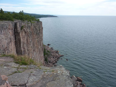
Even if you don't have a boat on a trailer, you can still enjoy the deck at the launch with its dramatic view back down the shoreline. Bring your own folding chair and pretend that you're North Shore royalty. 

Great Feature 3: Gitchi Gami Trail
The Gitchi Gami bike trail heads through Twin Points pines
Bring your bike and explore the shore! Twin Points is in the middle of the longest contiguous section of the Gitchi Gami bike trail. From Twin Points, you can ride west into Gooseberry Falls State Park and check out the waterfalls, or ride east into Split Rock Lighthouse State Park. As far as I know, those parks are still open for access by bike or by foot. 

How to get there

The entrance to Twin Points is at mile marker 42, three miles east of the entrance to Gooseberry Falls State Park. Look for a small brown sign that indicates public water access, then notice two large parking lots on the lake side of the highway. That's your turn. You'll see the large sign for Iona's Beach at the left-hand parking lot. 

Note on necessities
While the entrance to Twin Points should be open, the outhouses may not be. Buy some gas and goodies in Beaver Bay or Two Harbors before you get to Twin Points and use the facilities at the store.

Thursday, July 7, 2011

Heritage Days: A great North Shore festival this weekend


Some North Shore towns seem to have a festival every weekend from May to October. Not to name names, but I'm thinking of a certain town that rhymes with "Brand Hooray".

No such festival overload in Two Harbors. The city on Agate Bay saves all their festing for one big weekend in July. This weekend, head for the Two Harbors Heritage Days Festival.
The festival runs from today through Sunday, July 10. The Minnesota Old West Society has already set up their camp by the depot. Friday is music and dancing all day, including a vocal performance with Lake County natives Andrew Gangestad and Nathan Herfindahl. Oh, and there's a Lutefisk Toss at 4:00.

The big day is Saturday, with the parade at 1:00, music all day at the Heritage Days Stage, and a special concert with the Duluth Superior Symphony Orchestra at the historic bandshell.

Take some time away from the festivities to walk around Lighthouse Point. Look for blooming butterwort in the open Lake Superior ledgerock. Head out the slender breakwater to the lighthouse. Make the most of this one great weekend in Two Harbors!

Wednesday, July 6, 2011

Book review: A View of the Lake

For every 100 people who dream of leaving the big city (or the big suburbs) behind and moving to the North Shore, one or two people actually do it. That ratio has brought enough people to populate the North Shore with quite a cast of characters who have chosen to make this rough land their home.

In A View of the Lake, Beryl Singleton Bissell chronicles the leap of faith she and her husband Bill took in 1999 when they landed in quiet Schroeder, Minnesota, surprised owners of a run-down home they bought only for the view of Lake Superior.

Beryl and Bill immersed themselves in the community right away. I first met them when they were about four years into their new North Shore lives and Beryl was already busy and respected. In this book, Beryl shares how their community connections gradually unfolded.

Contemplating this transition into the North Shore community, Beryl writes, "What was it, I wondered, that brought a sense of belonging to place? ... Was it something we can make happen, or was it more tenuous, a gift?"

Belonging to the North Shore comes to them through neighborly interactions at the Schroeder Post Office, repeated hikes on their closest stretch of the Superior Hiking Trail, quiet writing retreats and epic adventures. I have a bit part in the book myself, as the guy who led them out onto the ice of Lake Superior.

If you've ever considered making a move like this, to the North Shore or Montana or Manhattan, this book is an important read. It reminded me of Rick Bass' Winter: Notes from Montana. In fact, Bissell's book would be strengthened with more of the chronological, narrative style of Bass' Winter. Bissell's short chapters are easy to read, but they keep the reader distant from the truly interesting underlying storylines.

The couple's move to the North Shore became complete when they purchased a family grave plot at the Schroeder cemetery (for the resident price of four dollars). It was final evidence of their determination "to make this our home 'till death do us part." The North Shore and its fans are better off now with these new "locals."

Tuesday, July 5, 2011

Sugarloaf: Despite the shutdown, your own North Shore state park

Margie Menzies, amazing summer naturalist at Sugarloaf Cove
Minnesota State Parks are closed this week. And probably next week, too. If you're on the North Shore and you need your state park fix, head for Sugarloaf Cove. You'll find a hiking trail, quiet Lake Superior beaches, interpretive programs, and one super summer naturalist at the heart of it all. 

Sugarloaf Cove is a state scientific and natural area; it's managed by a private nonprofit organization, so it's still open despite the state government shutdown.

Here are four reasons why you need to go to Sugarloaf Cove now:
  1. It's open! You don't have to park along Highway 61 and climb over the barricades to reach Sugarloaf, just enter the parking lot at mile marker 73.3 west of Schroeder. 
  2. It has a great one-mile interpretive trail. Learn about historic log rafting, ancient geology. and current ecological restoration, then hang out on a quiet cobblestone beach.
  3. Margie Menzies. Margie is the summer naturalist on site, and brings decades of natural history and education experience. She can answer nearly any question you might have about the North Shore, from boulders and basalt to black-throated blue warblers. Check out the Sugarloaf website for her regularly scheduled interpretive programs.
  4. New path! Follow the new trail straight from the parking lot to the "nature center." It leads right into the woods and across a fancy new bridge.
New bridge at Sugarloaf
We'll get Gooseberry, Tettegouche and Cascade back soon enough. For now, check out the wonders of Sugarloaf Cove.
 

Friday, July 1, 2011

Minnesota state parks are closed: alternate North Shore campgrounds

Yes, the terrific North Shore state parks are closed due to the Minnesota government shutdown. Even if you made reservations for that prime campsite a year ago for this holiday weekend, you can't use it. Plan A has gone down the drain.

Where else do you camp? You need a Plan B. For campsites right on Lake Superior, the only options left are private campgrounds and municipal campgrounds. They have already absorbed the overflow from the state parks and are full.

I recommend hitching up your sense of adventure and heading inland for a campsite in the Superior National Forest. To camp the North Shore this is the weekend you need a copy of my book, Camping the North Shore: A Guide to the 23 best campgrounds in Minnesota's spectacular Lake Superior region. You'll find detailed directions and descriptions for lovely campgrounds such as Crescent Lake, Two Island Lake, and Temperance River. If you're willing to go off the beaten path, you'll find free rustic campgrounds along trout streams, on the edge of the BWCA.

As you head through Duluth to the North Shore, pick up a copy of this book at Duluth Pack Store, the Bookstore at Fitgers, or any Holiday Store. 

Plan B: Head up the Cramer Road
The lucky folks already camped at lovely Ninemile Lake won't like me for telling you this, but I'd recommend heading to that campground first. From Finland, head east and north on the Cramer Road (County Road 7). The Ninemile Lake campground is about ten miles out of Finland. If all 24 sites are full there, keep heading inland on County Road 7 to check out the rustic campgrounds at Harriet Lake and Hogback Lake. You might end up all the way inland at Kawishiwi Lake, but it will be lovely, quiet, and free.