Tuesday, October 26, 2010

Fog dog: Before the storm

The biggest storm of the fall (so far) is rolling through Minnesota today. Before the big blow, I took Chloe out for a spin on the Superior Hiking Trail. Duluth has been decked in in fog since Sunday; as I drove up 40th Avenue West we entered the cloud bank and stayed there for the whole hike.

We hiked west from 40th Avenue West along the SHT toward Peace Ridge. The SHT in Duluth runs through four or five long stretches of what I call "dwarf forest." Aspen, oak and maple are growing there, but the soil is so thin and the climate so exposed (really? In Duluth?) that the trees only grow about 20 feet tall.

The combination of the fog and the dwarf forest made the short hike kinda spooky. The views are spectacular from Peace Ridge, taking in all of western Duluth and the St. Louis River. All I could see yesterday was fog. The sounds of the city, however, were everywhere, dispersed and resonating in the fog.

My destination was this rock looking southwest over Peace Ridge. I remember this as "the last happy place." On September 11, 2001, I sat here with Gayle Coyer of the Superior Hiking Trail Association, geologist John Green, and outdoor writer Sam Cook. We knew that the planes had hit the World Trade Center and that one of the towers had collapsed, but we didn't know about all the wars and pain to come.

In a sense, we were in a fog that day too. The world was noisy and changing around us, but we only saw what was in front of us. A storm was on the way.

But today's storm will pass and we'll all survive just fine.

Monday, October 25, 2010

Snow buntings

Driving from Ely to the North Shore yesterday, I was stunned and thrilled by the flocks of snow buntings rising from the road as we passed. Photos were simply impossible, since we were going at least 60 mph and the birds popped up without warning. But the beauty of the flock in flight, the flashing of dozens of white wings, called out for something, somehow, to capture it.

Maybe some snow bunting simile?

Half-burnt aspen leaves, caught in the updraft, rise and dance from the burn pile.

Snowflakes scatter from the road, up and out and away, only there is no snowstorm.

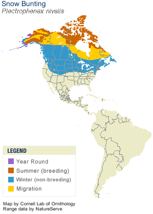
Snow buntings, according to the Cornell Lab of Ornithology,  are migratory birds for whom Minnesota is "south." They nest in the high Arctic. There, the males arrive weeks ahead of the females, in the long long sunrise of the Arctic spring. Prime nesting sites are deep in rock crevices, which the males line with their own feathers. The birds we see here are scrubby brown and white, with dramatic flashes of bright white when they fly. The males rub off that winter plumage to line their nests and to reveal their summer plumage of all black and all white.

The best photo of snow buntings in flight I could find online comes from the website of Donald and Lillian Stokes.  Check it out!

Wednesday, October 20, 2010

If only moose could vote

 Announcing the US government's new program!  Money for Moose! Cash for Cows! Bucks for Bulls!

A crowd of scientists, environmentalists and state agency folks gathered by Duluth's Aerial Lift Bridge yesterday morning to hear the good news: Money is rolling into Duluth and the North Shore...for moose habitat! Congressman Oberstar, in the tightest race in his career, was there to share the good news.

After surviving a cantankerous debate at 8:00 AM, in which supporters of Oberstar and his opponent Chip Cravaak got loud and rowdy, drowning out the actual debate, Oberstar was probably delighted to be back among supporters. And what was not to like? The Great Lakes Restoration Initiative is funding $200,000 for moose habitat and research in the forests above the North Shore. Plus $600,000 to plant trees and restore streamsides in Duluth's western neightborhoods. Another 200K for the PCA to strategize its work in the St. Louis River. 


 The moose project will "(a) restore 200 acres of moose foraging habitat near wetlands; (b) evaluate use of about 800 acres of previously restored moose foraging habitat; and (c) monitor how GPS-
radiocollared moose utilize the restored sites. This project will improve physical, chemical, and biological processes and ecosystem functions, and will help maintain or improve conditions for native fish and wildlife." All for $193,432.00.

If only moose and trees could vote...

Friday, October 15, 2010

Where Edward Hopper met the subway busker


On my way back from some field research on the North Shore's Sucker River this week, I stopped for lunch at the McQuade Harbor off Scenic Old Highway 61. If you appreciate the power of engineering to solve almost any problem, this is a great stop. Planners pulled out all the stops to 1) make the water deep enough for boats with underwater dynamite, 2) hold off the storm waves of Lake Superior with massive breakwalls, and 3) ensure no pedestrian gets run over on sleepy 61 by installing a tunnel under the highway. What had been basically just eroding shoreline has turned into a full safe harbor and recreation destination.

It is also a great stop for artists.

First, who knew that Edward Hopper based his famous painting "Rooms by the Sea" on this North Shore tunnel?

Second, the acoustics in the tunnel are fantastic. Sounds echo and fade out for at least a full second, like in a cavernous subway station. I could totally imagine a saxophone player or violinist playing, the tunnel resonating their music and projecting it out onto Lake Superior. 

So grab your brush and canvas, pack up the cello or the flute, and head to McQuade for fun and inspiration. And keep your eyes and ears out for the NEW tunnel at the Split Rock River Wayside.

Tuesday, October 12, 2010

A special hiking season


It's time to hit the ski trails...without your skis. 

For a brief few weeks in the fall, a whole new set of hiking trails open up on the North Shore. Some of the cross country ski trails make for EXCELLENT hiking, once they've had their preseason mowing. The last few weeks have been pretty warm and sunny up here, so muddy patches may have dried up. Ski trails also provide the best crunch-crunch-crunch of walking through six inches of crispy maple leaves just fallen from the trees.

One of my favorite ski trails for hiking is at Hartley Nature Center in Duluth. Most of the ski trails in the state parks are maintained for hiking as well and should be in good shape this fall.


However, some ski trails run right through woodland swamps. This isn't a problem in winter, since everything is frozen up. Even in a dry summer, however, these trails can be a hassle to hike. Above is the Bardon Peak loop on the Magney-Snively ski trail in Duluth. That trail system has many wet areas in the summer. 

Sunday, October 10, 2010

Into tall pines


The best pine forest on the Minnesota shore of Lake Superior isn't on the North Shore...it's on the west shore, Duluth's long stretch of sand spit known as Minnesota Point. Tall white and red pines rise out of the rolling dunes and frame views of the open blue lake beyond. They are so perfect they're part of a state Scientific and Natural Area.

Sally and I left the boys at home this afternoon and took the poodle out for a walk at "The End," the locals' name for the forest and dunes at the southern end of Minnesota Point. The Park Point Trail is a favorite of many Duluthians, and today was no exception: the parking lot by the airport was full and there were more than enough hikers to keep Chloe on edge the whole time we were out.

Under the canopy of one stretch of these pines, an old family cabin still stands, boarded up against vandals but with the loveliest view of the Superior Harbor. I could totally hang there for hours stretching into days with the wise pines.

Tall pines humble me and pull at my memories. I feel like a child walking at knee level of the wise old ones. I've hiked six miles through the California redwoods to see the world's tallest tree, and I've joined in a group tree hug of the giant spruce of the Olympic rainforest, and those are nice. But it's the needle-strewn pine trees of northern Minnesota, be they shorter and drier, that really move me.

The tall pines of Minnesota Point recently faced a severe threat from the Sky Harbor Airport's incessant need for open space for the occasional small plane. With the power of the FAA and the weight of a few influential plane owners, the airport has been trying to keep the approach path to the runway clear of those darn tall trees, and a year or so ago  announced plans to cut hundreds of them down, and top off hundreds more. Here's some background from Minnesota Public Radio:
Encroaching trees a safety concern at Duluth airport | Minnesota Public Radio News

Fortunately, a compromise is being worked out and most of the pines will still stand. Come on down to The End yourself; you won't be disa-"point"-ed.

Wednesday, October 6, 2010

Best fall colors? Duluth has them now


The best North Shore fall colors are now in Duluth. Hit the Superior Hiking Trail west of Spirit Mountain and find lovely maple and white pine woods. The SHT runs through old-growth maple forest for over a mile. About half the leaves have fallen from the trees, carpeting the forest floor.

In The Guide to the Superior Hiking Trail, this section is called "Munger Trail at 123rd Ave. W. to Magney Snively Trailhead." It's also on the SHT website.

From the Boundary Ave. exit of I-35, head south on Skyline Drive through the Spirit Mountain area, a total of 2.5 miles from the freeway. There's a SHT parking lot on the left that's also used for the Magney ski trails. Hike west (or south, really) from the parking lot right into a lovely forest of tall old white pine interspersed with flaming yellow maples.


The pines are as dark as the maples are bright. You can hike about two miles west on the trail to Bardon Peak, where views open up of Duluth and the St. Lous River valley below.


Today, even the poodle had a great time:

Friday, October 1, 2010

Fall colors: get off the highway


North Shore fall color fans know that there are typically two different peak times for the autumn spectacle. First the maple trees in the inland ridges turn ablaze. Then, two or three weeks later, the birch along Highway 61 change to gold.

The tourism boosters don't want you to hear this: those two color peaks are happening at one time. And, compared to other years, Highway 61 fall colors are not all that great.

After experiencing an early spring, the trees by Lake Superior must be ready to hang it up for the year. Along Highway 61, the aspens are in burnished colors of fall, not their typical glimmering yellow. After years of gradual decline and a devastating 2008 ice storm, the paper birch trees along Highway 61 have really suffered and so have their fall colors. You see more of their white bark than of their yellow leaves.

Fall is still the best time to hike the North Shore's fantastic trails. The views are still gorgeous. The trails are dry and the bugs are gone. You just have to get off of Highway 61. Either head inland to the Superior Hiking Trail and the Superior National Forest or get down to the shoreline in a state park like Split Rock Lighthouse, where you can walk for miles along the lakeshore.

Colors are near peak now in the new stretch of the Superior Hiking Trail between Duluth and Two Harbors. Try the six-mile round trip hike from the Rossini Road trailhead to the cute little waterfall on McCarthy Creek.