Monday, October 28, 2013

Stay safe this North Shore deer season

From http://www.fs.usda.gov/detail/conf/learning/safety-ethics/?cid=FSM9_029237

For a few weeks every year, the North Shore fills with hunters. While I'm glad those hunters are out there controlling the deer herd, I also know to change my outdoor plans dramatically. You can still hike and explore the North Shore, you just have to plan ahead. 

Firearm deer season starts in about ten days, on Saturday, November 9, and runs to Sunday November 24. That stretch of days includes three weekends in a row. If you've been meaning to get out in the woods for one more fall hike, one last mushroom expedition, one special picnic, now is the time to do it.

Grouse season is already underway, so many of the local trails have hunters on them. But those hunters are using shotguns and dogs; you'll see them coming and there's little danger of a stray bullet.

Deer season in the state parks
When deer season starts up, you can still find public places to get out and explore nature. Most of the North Shore state parks ban deer hunting in their most popular areas. SOme of them ban non-hunters from their backcountry. It's safe to say there won't be deer stands propped up on the Jay Cooke Swinging Bridge.

From Jay Cooke to Grand Portage, here's a brief review of state park status:
  • Jay Cooke: No hunting during regular deer season. Special muzzleloader season December 7-11.
  • Gooseberry Falls: All park land between Highway 61 and the lakeshore is safe from hunting.
  • Split Rock Lighthouse: All park land between Highway 61 and the lakeshore is open for visitors and closed to hunting.
  • Tettegouche: All park land between Highway 61 and the lakeshore is open for visitors and closed to hunting.
  • Cascade River: Most of the lakeshore, campground and waterfalls ares is closed to hunting and open to visitors. Consult a map at the park to make sure.
  • Judge CR Magney: Stay away if you're not hunting. Hunting is banned in the campground area, but everything else is open for hunting, including the hike to Devil's Kettle. 
  • Grand Portage: Safe zone; there is no deer hunting in this state park. 
Deer season on the Superior Hiking Trail
Much of the SHT is closed during deer season to respect the local landowners the trail passes. The trail will be closed from the northern edge of Duluth all the way through Lake County to the Sugarloaf Road for the entire season. Stretches of trail in Cook County will be closed as well. Check the SHTA Conditions webpage for more details.

Anywhere in deer season
If you do go out on the trails, wear blaze orange. If you don't have any, you can stop at a local convenience store or sporting goods store and buy a stylish orange wool cap or a cheap orange plastic vest.

What are your tips for a safe and enjoyable North Shore deer season?

Friday, October 11, 2013

North Shore fall colors: Past their peak

Twice in the last two days I've driven from Duluth up to the middle of the North Shore. On Thursday, we were actually looking for fall colors and a glorious hike. Today it was just for a meeting, but I kept my eyes out.

Here's my blow-by-blow, tree-by-tree analysis:

Maples: 
Pool in a woodland stream, Section 13 hike
The famed sugar maple forests of the North Shore ridgelines are nearly done. Entire hillsides of maple trees are barren. Yellow maple leaves carpet the forest floors. Some smaller maples, tucked into the protection of a forest, still have some yellow leaves. Driving through Finland, there was hardly a colored maple leaf left on the trees.

Ironically, there is one glorious orange maple right by the highway where it passes through Gooseberry Falls State Park. Don't let this tree, obviously planted by a landscaper, fool you. The maple season in the heart of the North Shore is nearly over.

Oaks: 
Red oak leaves, Section 13 trail
 Most of the red colors in the inland areas, like on our hike yesterday to Section 13, were on the red oak trees. The red of red oak leaves can be luscious, like lipstick. The oaks tend to stand by themselves in rockier, shallower soil, not in thick groves like the maple. So each colorful oak tree really popped.

Aspen:
Aspens glow yellow, oaks red below Section 13 cliffs
Along Highway 61, clusters of aspen ranged from fully green-leaved to completely empty of leaves. Their color gets better the further we went up the shore. Many solo aspens along the highway and on the hillsides were glorious fountains of golden yellow.

Birch:
What birch? Especially along Highway 61, the birch are virtually all died out. Their white bark still stands, providing nice contrast to the other, still living trees.

If you're looking for fall colors this week, I'd recommend sticking to the Highway 61 corridor. Go for a walk on the ski trails at Split Rock Lighthouse State Park. Hit the Superior Hiking Trail to Elys Peak in the western part of Duluth. There's still lots of lovely autumn out there still, you just might have to look for it.

Saturday, October 5, 2013

Hiking to Two Harbors, Leg 6: Normanna Rd. to Sucker River

A welcome sign at the Normanna trailhead
I played hooky this week and got back on the Superior Hiking Trail. I wanted to make some progress on my big "summer" goal of hiking all the way to Two Harbors. Five day hikes in, I had made it to Normanna Road, on the northeast outskirts of Duluth.

After hiking on everything from city sidewalks to snowmobile trails, after hiking through everything from farmfields to graveyards, after hiking with everything from baby strollers to ATV's, I was thrilled to be on a real hiking trail. This section of the SHT is nine miles long. On this hike from Duluth to Two Harbors, this was the first pure and simple hike, just foot travel, no wide snowmobile trails or paved walkways.

Me in some maple woods
Just a few hundred yards in, I had to literally stop and tighten my boot laces. On a classic SHT layout, the trail winds up and over woodland ridges, over boulders, down steep streambanks, and more. For the first time in a long run of hiking trail, I actually had to hike.I loved it.

The SHT here is nearly all on state or county forest land. Some of the highlights along the trail section are beaver ponds and the open beaver meadows, a classic North Shore ridgeline maple forest, just starting to turn yellow and orange, and the scenic gurgles of the Sucker River.


Even the older logged areas, cut over two or three years ago, had some beautiful fall flowers.

Asters blooming in October in a logged area

Nine miles is a decently long hike, and I was starting to feel the wear in my joints toward the end. I had driven to the ending trailhead on Fox Farm Road and ridden my bike nearly ten miles along dirt and paved road to the starting trailhead, so I had already pushed my middle-aged body more than I would at a typical day at the office.

So just when I felt I was in my little hiking nirvana...

The SHT goes straight through that brush pile

A bit tired, a bit elated from actually hiking in actual woods, I was thrown off my game in the last mile, as the trail entered an active logging area. I'd heard the rumble of engines and the hum of saws for a good half hour. Then the SHT ran right into an opening that, based on the smell of sawdust and equipments, had probably been cut in the last 48 hours. The only sign of the SHT was the occasional strip of pink flagging on the small trees left standing.

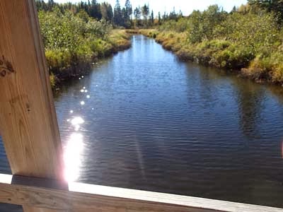
From the A-frame bridge over Sucker River.
I made it through the logging area by dumb luck and persistence. The final crossing of the Sucker River was lovely, and I was proud and pleased to complete my bike-hike circuit.

Apparently, the next section of the SHT has even more logging activity. I'm letting my feet heal, dusting off my GPS, and planning another day in the woods next week.